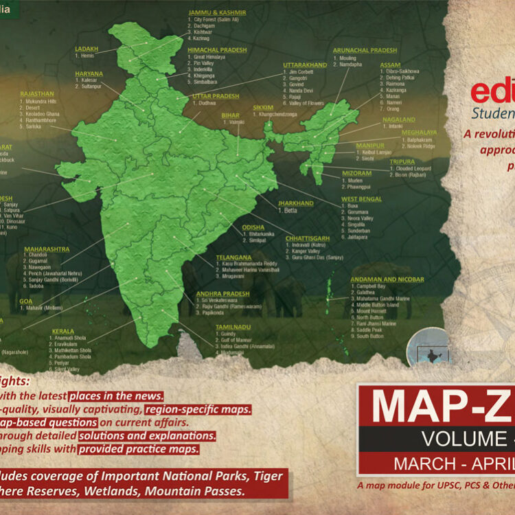
Manas National Park
[Introduction] It is a National Park, a UNESCO Natural World Heritage Site, a Project Tiger Reserve, an Elephant Reserve, and a Biosphere Reserve.
- It is one of the first reserves included in the network of tiger reserve under Project tiger in 1973.
- In 1985, the Manas Wildlife Sanctuary was inscribed as a World Heritage Site.
- In 1989, Manas acquired the status of a Biosphere Reserve.
- In 1990, it was declared as a National Park.
- In 2003, it was declared as Chirang – Ripu Elephant Reserve under Project Elephant.
[Location] It is located in the Himalayan foothills in the contiguous range with the Royal Manas National Park in Bhutan.
[Geography] Manas is located in the foothills of the Eastern Himalaya and is densely forested.
- The Manas Biosphere Reserve extends over an area of 2837 km2 from Sankosh river in the west to Dhansiri river in the east, with a core area of 500 km2 of the National park.
[Vegetation] The Manas lies in the monsoon forests in the Brahmaputra Valley semi-evergreen forests ecoregion.
- About half of the Park is covered by Grasslands of Terai and Bhabar type.
- Major Vegetation types in the park are:
- Sub-Himalayan Light Alluvial Semi-Evergreen forests in the northern parts;
- East Himalayan mixed Moist and Dry Deciduous forests;
- Low Alluvial Savanna Woodland; and
- Assam Valley Semi-Evergreen Alluvial Grasslands which cover almost half of the Park.
[Wildlife] The park is known for its rare and endangered endemic wildlife that are not found anywhere else in the worldsuch as the Assam roofed turtle, hispid hare, golden langur, and pygmy hog. It is famous for its population of wild water buffalo.
- Manas is very rich in the population of Royal Bengal Tigers.
- Indian Rhinoceros was re-introduced in 2007 after extinction due to heavy poaching during the Bodo uprising.
- Manas boasts the largest population of the endangered Bengal Florican in the world and is also a great place to see the Great Hornbill.